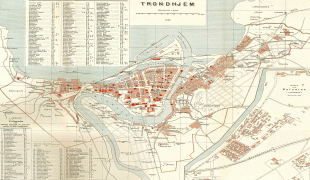
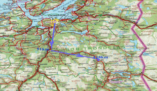
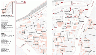
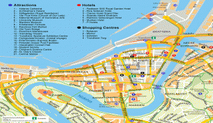
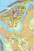
Trondheim
 |
 |
The settlement was founded in 997 as a trading post, and it served as the capital of Norway during the Viking Age until 1217. From 1152 to 1537, the city was the seat of the Catholic Archdiocese of Nidaros; it then became, and has remained, the seat of the Lutheran Diocese of Nidaros, and the site of the Nidaros Cathedral. It was incorporated in 1838. The current municipality was formed in 1964, when Trondheim merged with Byneset, Leinstrand, Strinda and Tiller, and further expanded 1 January 2020, when Trondheim merged with Klæbu.
Trondheim has a mild climate for its northerly latitude, resulting in moderate summers and winters that often remain above the freezing point in seaside areas. At higher elevations, though, the microclimate is colder and snowier.
The city functions as the seat of the County Mayor of Trøndelag county, but not as its administrative centre (which is Steinkjer). This is designed to avoid making the county administration too centralized.
Trondheim is home to football club Rosenborg, Norway's most successful team, as well as Granåsen Ski Centre which has hosted the World Championship in Nordic Skiing.
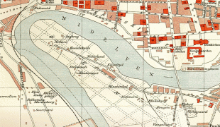
The city was originally given the name by Olav Tryggvason. It was for a long time called Nidaros (river Nid's outlet), or Niðaróss in the Old Norse spelling. But it was also just called kaupangr ("city") or, more specifically, kaupangr í Þróndheimi ("the city in the district Þróndheimr", i.e. Trøndelag). The name Trøndelag, Norse Þrǿndalǫg, originally meant «the law area of the Trønder (people)» (literally Trønder-law). The first part is the genitive plural of the popular name þrǿndr, «trøndere», which is an old present participle of the verb þróask, «to grow» (with the same root as in «thrive»), and thus can be translated as «the strong, fertile».
During the late Middle Ages people started to call the city just Þróndheimr. In the Dano-Norwegian period, during the years as a provincial town in the united kingdoms of Denmark–Norway, the city name was spelt Trondhjem.
Following the example set by the renaming of the capital Kristiania to Oslo, Nidaros was reintroduced as the official name of the city for a brief period from 1 January 1930 until 6 March 1931. The name was restored in order to reaffirm the city's link with its glorious past, despite the fact that a 1928 referendum on the name of the city had resulted in 17,163 votes in favour of Trondhjem and only 1,508 votes in favour of Nidaros. Public outrage later in the same year, even taking the form of riots, forced the Storting to settle for the medieval city name Trondheim. The name of the diocese was, however, changed from Trondhjem stift to Nidaros bispedømme (Diocese of Nidaros) in 1918.
Trondheim was briefly named Drontheim during the Second World War, as a German exonym.
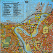
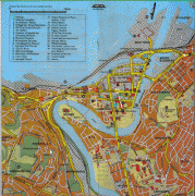
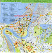
Map - Trondheim
Map


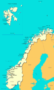


Country - Norway
 |
 |
| Flag of Norway | |
Norway has a total area of 385,207 km2 and had a population of 5,425,270 in January 2022. The country shares a long eastern border with Sweden at a length of 1,619 km. It is bordered by Finland and Russia to the northeast and the Skagerrak strait to the south, on the other side of which are Denmark and the United Kingdom. Norway has an extensive coastline, facing the North Atlantic Ocean and the Barents Sea. The maritime influence dominates Norway's climate, with mild lowland temperatures on the sea coasts; the interior, while colder, is also significantly milder than areas elsewhere in the world on such northerly latitudes. Even during polar night in the north, temperatures above freezing are commonplace on the coastline. The maritime influence brings high rainfall and snowfall to some areas of the country.
Currency / Language
| ISO | Currency | Symbol | Significant figures |
|---|---|---|---|
| NOK | Norwegian krone | kr | 2 |
| ISO | Language |
|---|---|
| FI | Finnish language |
| SE | Northern Sami |
| NO | Norwegian language |
| NN | Nynorsk |